
General
The present Web Application using Google Maps API allows users to access detailed information about Vietnam largest river basins on their stream networks, essential data on meteorology, hydrology, land cover / land use, the updated information on industrial zones, hydropower, reservoirs, minings, etc.As of November the 15th, 2018 information and data of 10 river basins namely Hồng – Thái Bình, Bằng Giang – Kỳ Cùng, Mã - Chu, Cả, Hương, Vu Gia - Thu Bồn, Ba, Sê San - Srê Pôk, Đồng Nai and Cửu Long (Mekong Delta) can be accessed through the present web application. The present website is expected to be updated in a near future with spatial and attribute data of other river basins in Vietnam.
Any comment / suggestion to the web application is welcomed. Please send your feedback to rivervietnam@gmail.com.
Contents of the 10 Việt Nam Largest River Basins Web Mapping
Meteorology, Hydrology, Topography and Land Cover/Land Use
Spatial information and data on hydrometeorology, topography and LC/LU can be accessed by mouse clicking to any symbol/objects.- Hydrology : Watershed boundary, river and stream network, hydrological stations, Isolines for flow modules (long-term average values)
- Meteorology : Climate station, Isolines for rainfall (long-term average values)
- Topography : Digital Elevation Model
- Land cover / Land use
Hydropower plans, Reservoirs for irrigation, Minings, Industrial zones
Available information / data includes position and key features of each item.These spatial data can be visual represented with administrative layers of provincial and district boundaries as desired. .
Google Maps as Background Map
Since the tool uses Google Maps as its basemap it also contains all mapping tools / facilities of Google Maps such as zoom in/out, distance and area measurements, switching to sattelite images, etc.Thank Notes
We would like to thank the sponsers (Center for Water Resources Conservation and Development and Oxfam Novib) and all people who have suported development of this web application especially members of the Vietnam River Network.We sincerely expect receiving more comments and suggestions which are necessary for this web mapping development into a much more comprehensive and usefull to all intereted in Vietnam water resources development and protection.
Contents of the Data Layers
| River Basin | Map Data Layers | Completion Date |
|---|---|---|
| Hồng – Thái Bình river | HYDROLOGY: Catchment boundary, River and streams, Hydrological stations, Isolines of flow module, METEOROLOGY: Climate stations, Isolines of rainfall, TOPOGRAPHY: Digital Elevation Model, ADMINISTRATION: Boundaries of provinces and districts in the river basin, LAND COVER / LAND USE, and INFRASTRUCTURE: Hydrpower plans, Irrigation reservoirs, Minings, Industrical zones, More detailed data for Gâm river Basin from WARECOD. |
March 2017 |
| Bằng Giang – Kỳ Cùng river | HYDROLOGY: Catchment boundary, River and streams, Hydrological stations, Isolines of flow module, METEOROLOGY: Climate stations, Isolines of rainfall, TOPOGRAPHY: Digital Elevation Model, ADMINISTRATION: Boundaries of provinces and districts in the river basin, LAND COVER / LAND USE, and INFRASTRUCTURE: Hydrpower plans, Irrigation reservoirs, Minings, Industrical zones |
December 2017 |
| Mã - Chu river | HYDROLOGY: Catchment boundary, River and streams, Hydrological stations, Isolines of flow module, METEOROLOGY: Climate stations, Isolines of rainfall, TOPOGRAPHY: Digital Elevation Model, ADMINISTRATION: Boundaries of provinces and districts in the river basin, LAND COVER / LAND USE, and INFRASTRUCTURE: Hydrpower plans, Irrigation reservoirs, Minings, Industrical zones |
December 2017 |
| Cả river | HYDROLOGY: Catchment boundary, River and streams, Hydrological stations, Isolines of flow module, METEOROLOGY: Climate stations, Isolines of rainfall, TOPOGRAPHY: Digital Elevation Model, ADMINISTRATION: Boundaries of provinces and districts in the river basin, LAND COVER / LAND USE, and INFRASTRUCTURE: Hydrpower plans, Irrigation reservoirs, Minings, Industrical zones |
December 2017 |
| Hương river | HYDROLOGY: Catchment boundary, River and streams, Hydrological stations, Isolines of flow module, METEOROLOGY: Climate stations, Isolines of rainfall, TOPOGRAPHY: Digital Elevation Model, ADMINISTRATION: Boundaries of provinces and districts in the river basin, LAND COVER / LAND USE, and INFRASTRUCTURE: Hydrpower plans, Irrigation reservoirs, Minings, Industrical zones |
March 2017 |
| Sê San – Srê Pôk river | HYDROLOGY: Catchment boundary, River and streams, Hydrological stations, Isolines of flow module, METEOROLOGY: Climate stations, Isolines of rainfall, TOPOGRAPHY: Digital Elevation Model, ADMINISTRATION: Boundaries of provinces and districts in the river basin, LAND COVER / LAND USE, and INFRASTRUCTURE: Hydrpower plans, Irrigation reservoirs, Minings, Industrical zones |
March 2017 |
| Vu Gia - Thu Bồn river | HYDROLOGY: Catchment boundary, River and streams, Hydrological stations, Isolines of flow module, METEOROLOGY: Climate stations, Isolines of rainfall, TOPOGRAPHY: Digital Elevation Model, ADMINISTRATION: Boundaries of provinces and districts in the river basin, LAND COVER / LAND USE, and INFRASTRUCTURE: Hydrpower plans, Irrigation reservoirs, Minings, Industrical zones |
December 2017 |
| Ba river | HYDROLOGY: Catchment boundary, River and streams, Hydrological stations, Isolines of flow module, METEOROLOGY: Climate stations, Isolines of rainfall, TOPOGRAPHY: Digital Elevation Model, ADMINISTRATION: Boundaries of provinces and districts in the river basin, LAND COVER / LAND USE, and INFRASTRUCTURE: Hydrpower plans, Irrigation reservoirs, Minings, Industrical zones |
December 2017 |
| Đồng Nai, Sài Gòn, Vàm Cỏ rivers | HYDROLOGY: Catchment boundary, River and streams, Hydrological stations, Isolines of flow module, METEOROLOGY: Climate stations, Isolines of rainfall, TOPOGRAPHY: Digital Elevation Model, ADMINISTRATION: Boundaries of provinces and districts in the river basin, LAND COVER / LAND USE, and INFRASTRUCTURE: Hydrpower plans, Irrigation reservoirs, Minings, Industrical zones |
December 2017 |
| Cửu Long river | HYDROLOGY: Catchment boundary, River and streams, Hydrological stations, METEOROLOGY: Climate stations, Isolines of rainfall, TOPOGRAPHY: Digital Elevation Model, ADMINISTRATION: Boundaries of provinces and districts in the river basin, LAND COVER / LAND USE, and INFRASTRUCTURE: Irrigation reservoirs, Minings, Industrical zones |
December 2017 |
.
About Web Mapping
(The section is currently under development! Please come back later)Nội dung
Design of Requirements, Contents and Interface Data Preparation: Spatial data layers and Attributes, Format Transformation Javascripts Programming HTML Programming for Mobile Devices and Integration of Modules Reporting, Consultation, Testing, Installation and Update PlanningDesign of Requirements, Contents and Interface
. (Chi tiết đang trong quá trình soạn thảo)
Data Preparation: Spatial data layers and Attributes, Format Transformation
. (Chi tiết đang trong quá trình soạn thảo)
Javascripts Programming
. (Chi tiết đang trong quá trình soạn thảo)
HTML Programming for Mobile Devices and Integration of Modules
. (Chi tiết đang trong quá trình soạn thảo)
Reporting, Consultation, Testing, Installation and Update Planning
. (Chi tiết đang trong quá trình soạn thảo)
| No | Item | Description |
|---|---|---|
| 1 | Module 01 | 40 |
User's Guide
| Step | Description | Image |
|---|---|---|
| 1 |
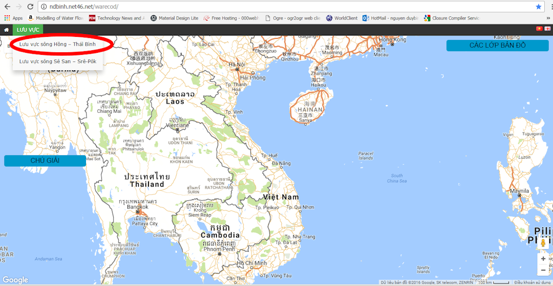
Giao diện khi mở ra sẽ như Hình 1. Menu ‘Lưu vực’ (có vòng tròn và mũi tên trong Hình) là điểm nhấn chuột để Danh sách các lưu vực hiện lên, cho phép người dùng chọn Lưu vực. |
 |
| 2 | Để chọn lưu vực “sông Hồng – Thái Bình” bạn cần nhấn chuột vào tên lưu vực H-TB (vòng trong tô đỏ trong Hình 2). Khi đó phía bên phải cửa sổ giao diện sẽ hiện lên Danh mục dữ liệu bản đồ. |
 |
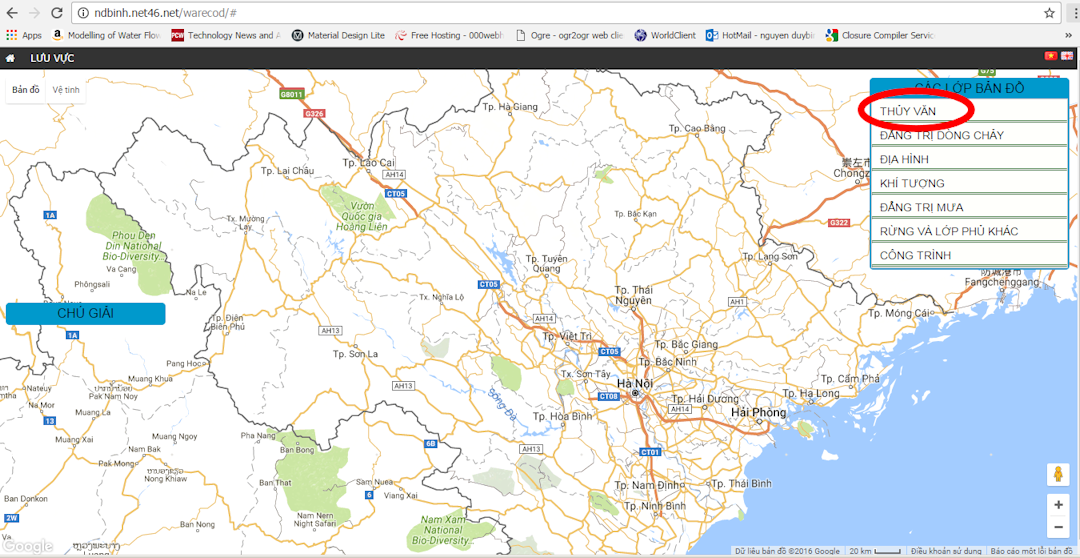
| 3 | Để mở Danh mục chi tiết các hạng mục Bản đồ (Hình 3) bạn cần Nhấn chuột HAI (02) lần, ví dụ vào cụm từ “THỦY VĂN”. Lúc đó sẽ hiện Danh mục chi tiết các dữ liệu có thể xem. |
 |
| 4 | Mối loại dữ liệu đều có 1 checkbox (để hiện bản đồ hay tắt bản đồ) và 1 nút để tải tập tin shapefile dạng zip như Hình 4. Chi tiết về các thực thể bản đồ cũng có thể được kích hoạt khi người dùng nhấn chuột vào thực thể đó. |
 |
Campus Maps for Vietnam National University of Agriculture (VNUA)
The same authours has developed an interactive map for VNUA Campus in 2014-2015. The web mapping tool using Google Maps API allows user to locate graphically any building / academic unit / classroom with a simple mouse click. The floor layouts of most buidings can also be displayed visually.The website is fully mobile compatible using the state-of-the art Google Material Design concept. As far as we know, this web application is the 1st of its kind in the whole of Vietnam universities. There is also a VNUA Planning Mapping application whcih allows user to investigate what VNUA will become in a near future.